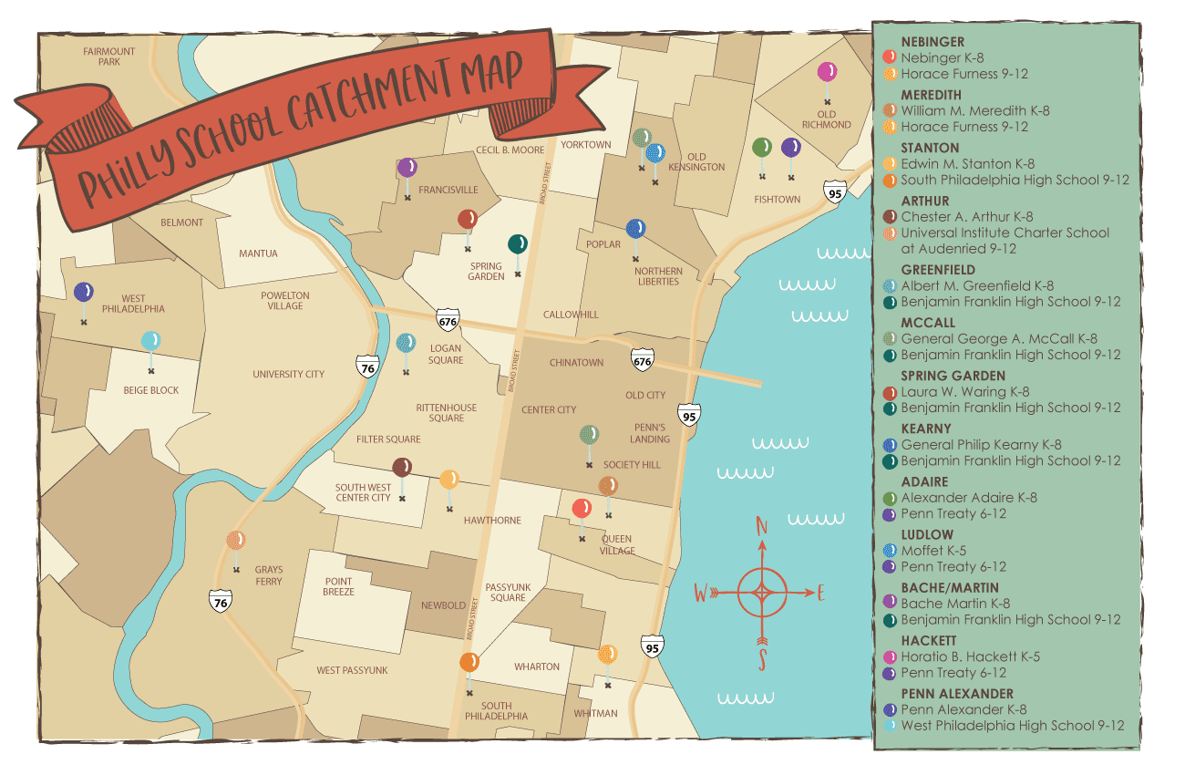
“Downtown” Philadelphia School Catchment Map
Public Schools in many changing neighborhoods of Philadelphia reflect their communities: diverse success stories which have shown steady improvement.

For home buyers, an improving school is a win-win to raise property values and make neighborhoods more desirable. This Philadelphia school catchment map, illustrated by Stephanie Frederick, is based on the city’s School Finder Tool. We hope this map will help our community get to know their neighborhood school and encourage them to recognize the school catchments.
Explore Philadelphia schools in each catchment below and leave a comment to share support for your neighborhood school with the Philly Family Community.
Hover, tap, and click to explore:
Queen Village & Bella Vista Neighborhoods
Nebinger, George W
Queen Village
& Bella Vista
Nebinger (K-8)
6th St & Carpenter St
Horace Furness (9-12)
3rd St & Mifflin St
Meredith, William M
Queen Village
& Bella Vista
William M. Meredith (K-8)
5th St & Fitzwater St
Horace Furness (9-12)
3rd St & Mifflin St
Graduate Hospital, Newbold, & Point Breeze
Stanton, Edwin M
Graduate Hospital, Newbold, & Point Breeze
Edwin M. Stanton (K-8)
17th St & Christian St
South Philadelphia High School (9-12)
Broad St & Snyder Ave
Marian Anderson Neighborhood
Graduate Hospital
Marian Anderson Neighborhood Academy (K-8)
20th St & Catharine St
Universal Institute Charter School at Audenried (9-12)
33rd St & Tasker St
Rittenhouse, Fitler Square, Center City West, Society Hill, Washington Square West
Greenfield, Albert M
Rittenhouse, Fitler Square, Center City West
Albert M. Greenfield (K-8)
22nd St & Chestnut St
Benjamin Franklin High School (9-12)
Broad St & Green St
McCall, General George A
Society Hill, Washington Square West
General George A. McCall (K-8)
6th St & Delancey St
Benjamin Franklin High School (9-12)
Broad St & Green St
Fairmount, University City, and West Philadelphia
Bache/Martin
Fairmount
Bache Martin (K-8)
22nd St & Brown St
Benjamin Franklin High School (9-12)
Broad St & Green St
Penn Alexander
University City and West Philadelphia
Sadie Tanner Mossell Alexander University of Pennsylvania Partnership School (K-8)
43rd St & Locust St
West Philadelphia High School (9-12)
47th St & Walnut St
Spring Garden, Northern Liberties, Fishtown
Spring Garden
Spring Garden
Spring Garden School (K-8)
12th St & Melon St
Benjamin Franklin High School (9-12)
Broad St & Green St
Kearny, General Philip
Northern Liberties
General Philip Kearny (K-8)
6th St & Fairmount Ave
Benjamin Franklin High School (9-12)
Broad St & Green St
Adaire, Alexander
Kensington
Ludlow
Kensington
James R. Ludlow School (K-8)
6th St & Master St
Penn Treaty (9-12)
Montgomery & Thompson St
Hackett, Horatio B
Hackett
Kensington
Horatio B. Hackett (K-5)
E York St & Trenton St
Penn Treaty (6-12)
Montgomery & Thompson St


Carla Brandoff August 17, 2024
Hi there.
You should add Kirkbride, Vare Washington and Henry Lea to these maps.